class: center, middle, inverse, title-slide .title[ # CRUSE ] .subtitle[ ## Cycle Route Uptake and Scenario Estimation Tool ] .author[ ### Robin Lovelace and Joey Talbot on behalf of the CRUSE team ] .institute[ ### University of Leeds, <a href="https://environment.leeds.ac.uk/transport">Institute for Transport Studies</a> ] .date[ ### Sligo, 2022-09-22 ] --- ### The problem Source: [wantedinafrica.com](https://www.wantedinafrica.com/news/cape-town-has-worst-traffic-in-south-africa.html)  -- Or is that a symptom of a deeper problem? --- ## The problem: root causes  Source: ['Inside the black box' report](https://www.co.pierce.wa.us/DocumentCenter/View/755/A-GuideToModeling?bidId=) -- - Transport models were designed to support growth in car ownership and reduce journey times (Boyce and Williams, 2015) -- - 21^st^ Century priorities are very different -- - Climate science, air pollution and health force a shift in focus - The concepts of 'participatory democracy' and 'citizen science' mean there is a need for collaborative solutions -- --- ## The solution **New technologies mean that open access transport models are possible**  Source: A/B Street, free, open source, gamified transport planning software [github.com/dabreegster/abstreet](https://github.com/dabreegster/abstreet/#ab-street) 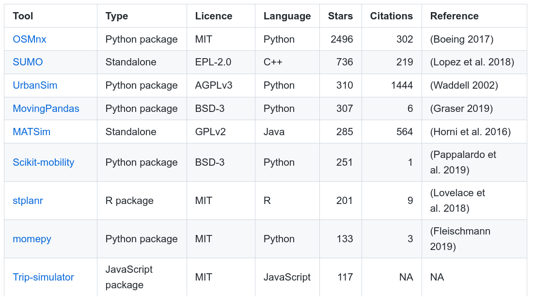 --- ## Direction of travel: WUIs 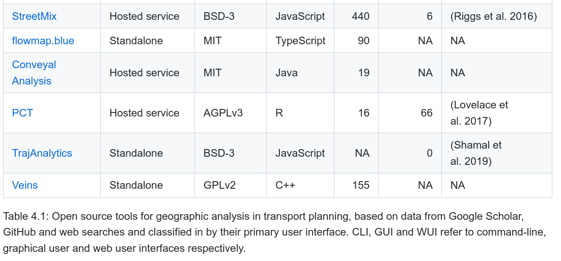 --- <!-- ##### Open Source Transport Tools. Source: [github.com/Robinlovelace/open-gat](https://github.com/Robinlovelace/open-gat#open-source-tools-for-geographic-analysis-in-transport-planning) -->  --- ## From open source to open access  - Transport models represent a leverage point in transport systems - New paper, Lovelace et al (2020) describes the emergence and possibilities for 'open access models' --- # The Propensity to Cycle Tools - Early prototype of the tool developed at Open Data Institute Leeds hackathon, 2015 - National deployment of the Propensity to Cycle Tool 2 years later ([PCT.bike](http://www.pct.bike/)) (Lovelace et al. 2017) 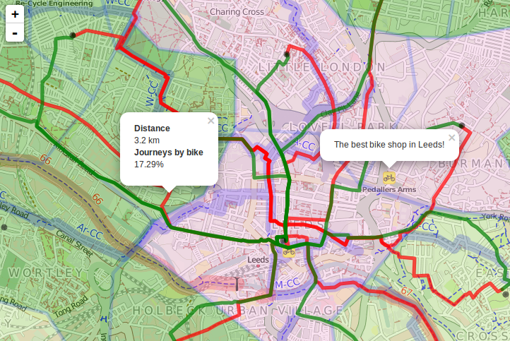<!-- --> --- ## Key aspects of the PCT - Based on open source code - Based on open data - Results published as open data - Publicly available web application encourages participation and evidence-based debate Open data and accessible results lead to participation. See https://twitter.com/search?q=cyipt.bike%2Frapid  --- ## How it works  --- ## Demo of the PCT Source: https://www.pct.bike/  --- # Active travel uptake modes The ActDev project: https://actdev.cyipt.bike/  - A/B Street - R integration, see https://github.com/a-b-street/abstr --- # CRUSE 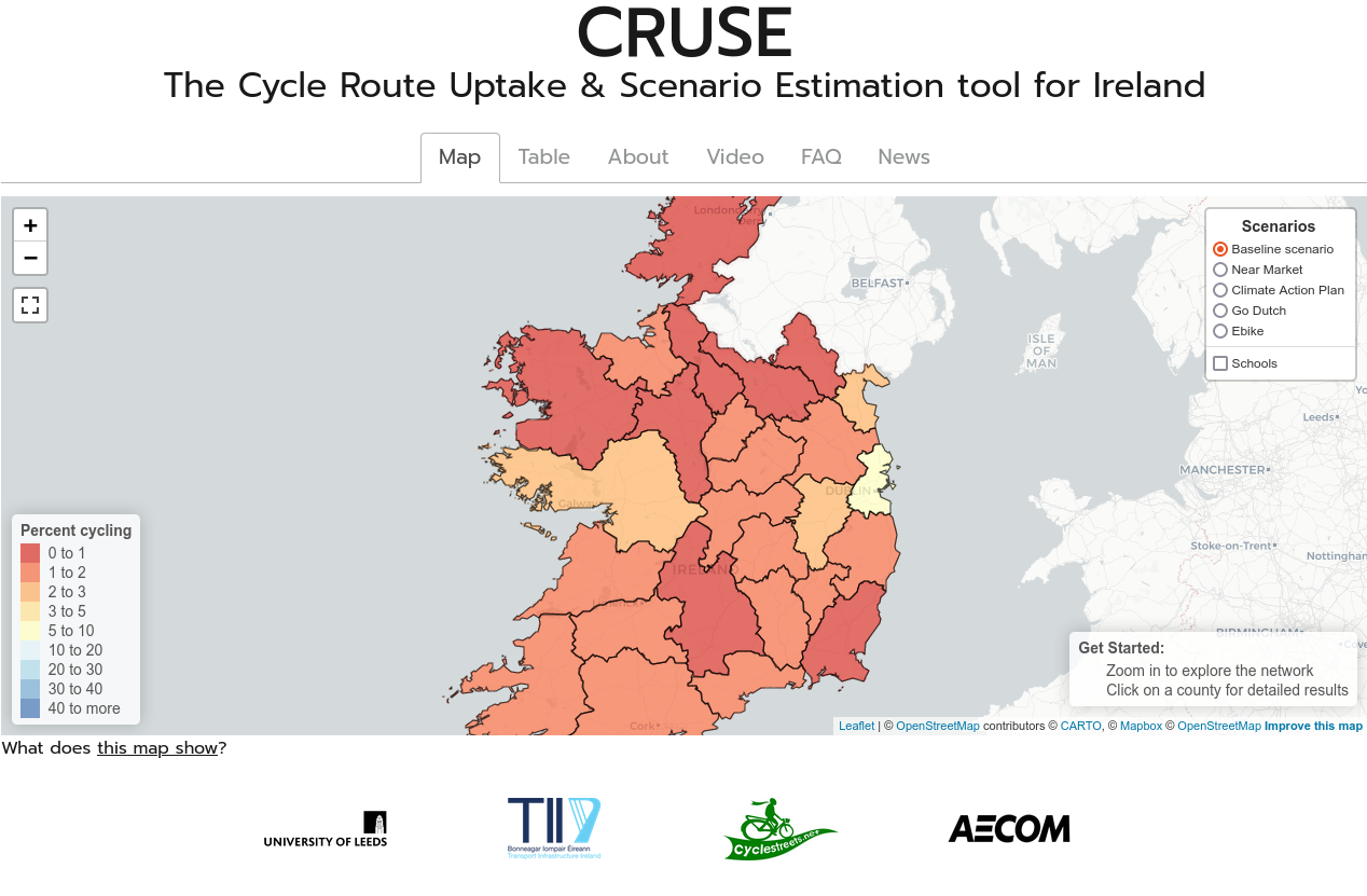 --- # Purpose of the CRUSE tool To provide a web application for strategic cycle network planning for Transport Infrastructure Ireland (TII). This will support TII in: - Meeting road safety obligations under the EU RISM Directive - Appraisal of Active Modes PE-PAG-02036 in existing and future schemes The tool involves detailed route-level visualisations and a range of cycling uptake scenarios  --- # What trip types are included? .pull-left[ POWSCAR (2016 Census): - Travel to work - Travel to school/college Other (2017 National Household Travel Survey): - Social, personal and shopping trips Coming soon: - Recreational trips ] .pull-right[  ] --- # Cycle route networks Journeys are routed on the road and cycle path network https://www.cyclestreets.net/help/journey/routing/ 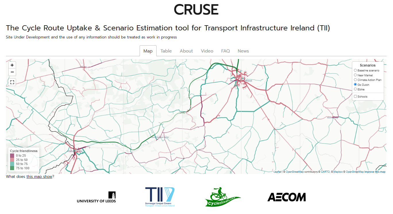 --- # What is cycle friendliness? .pull-left[ A subjective measure representing the quality of a route segment for cycling. Using data derived from OpenStreetMap, it incorporates factors such as: - Type of road - Presence of cycle infrastructure - Whether the cycleway is shared with vehicles or pedestrians - Speed limits - Surface quality - Cycle signage - Barriers or obstructions - Cycle path width ] .pull-right[  ] --- # What are the quietest, fastest and balanced route types? - People's preferences for cycle infrastructure will vary. Children, less experienced and leisure cyclists may prefer traffic-free off-road routes, while experienced commuter cyclists may prefer direct routes. - Ideally, a cohesive cycle network should cater for this, with options for both comfort and speed - In the CRUSE tool, we present three types of route network - balanced, quietest and fastest - The balanced route network is shown by default  --- # Cycle uptake scenarios Results shown for County Kildare  --- # County statistics - trip distance and mode Results shown for County Kildare  --- # County level results  Full route networks are available on the downloads page --- # Any questions?  --- # References Boyce, D.E., Williams, H.C.W.L., 2015. Forecasting Urban Travel: Past, Present and Future. Edward Elgar Publishing. Beimborn, E., Kennedy, R., 1996. Inside the Blackbox: Making Transportation Models Work for Livable Communities. Citizens for a Better Environment. Lovelace, R., Parkin, J., Cohen, T., 2020. Open access transport models: A leverage point in sustainable transport planning. Transport Policy 97, 47–54. https://doi.org/10.1016/j.tranpol.2020.06.015 --- #### Appendix: Reproducibility and extending the tool - Find commuting desire lines in West Yorkshire between 1 and 3 km long in which more people drive than cycle: ```r plot(desire_lines["bicycle"]) ``` <!-- -->