Progress Summary
This is a follow up to Housing Code Enforcement Project Plan which cites the data sources for this project, provides some preliminary statistics, and poses some questions whose answers can hopefully be found in the data.
Since then:
Because of the variable access performancee and permanence of the data sets, I uploaded snapshots of them to my GitHub account. My R programs and scripts will access them from there.
I have purged the Housing Code Violation (HCV) data set of all records that did not cite a code reference or had a disposition of “no violations found”.
I have assigned geocoordinates where the HCV had none. Using these geocoordinates, I associated each violation to a U.S. Census Block group.
Working from the County Code, I have constructed a data set that categorizes code references and assigns to a severity code of 1-5 (5 is most severe) and joined these to the HCV.
I have culled rental properties (mcRentalPp) from the Maryland Parcel Points data set (mcPp).
I have made alluvial plots that relate the features of the HCV.
Except for a trivial number of records, I failed to join the HCV and the mcRentalPp by either geocoordinates or street address.
Remaining
Join the HCV and Troubled Property data sets. Devise a model for the likelihood that an HCV property becomes a troubled property.
Produce geospatial plots of violations within census block groups. Provide a meaningful way of navigating between block groups.
Identify a story that can be told from the data. Illustrate it with alluvial plots or animated geospatial plots.
Revised Statistics
These were included in the Project Plan. Since cleaning:
Summary of Residential Rental Properties in Montgomery County
| 47106 |
109232 |
1 |
1 |
2.319 |
1 |
1121 |
Summary of Housing Code Violations 2013-2019
| 2013 |
8924 |
7392 |
3556 |
3070 |
26952 |
| 2014 |
10646 |
7525 |
3778 |
3714 |
21587 |
| 2015 |
10743 |
7251 |
3483 |
3803 |
26388 |
| 2016 |
11787 |
6887 |
3466 |
3873 |
39657 |
| 2017 |
10093 |
6771 |
3844 |
4098 |
51527 |
| 2018 |
11917 |
7575 |
4409 |
5083 |
71072 |
| 2019 |
11476 |
6899 |
3609 |
4079 |
200287 |
Categories of Code Infractions and Severity
This is my take summarizing the County’s Housing Code collapsing the sixty six infractions into twelve categories. This is still to many to render in a plot so I squeezed these down to classes: safety, security, habitability, and compliance:
Summary of Housing Code Infractions
| 3322 |
compliance |
3 |
29-5(c) |
availForInspection |
| 1642 |
compliance |
2 |
29-16(a) |
rentalHousingLicense |
| 399 |
compliance |
4 |
26-14(a) |
failureToBringCondemnedPremise |
| 315 |
compliance |
4 |
26-13(d) |
unauthorizedRemovalOfCondemnat |
| 298 |
compliance |
3 |
59-c-1.31(b) |
violationLandUses |
| 199 |
compliance |
5 |
26-15 |
failureToAbateSevereCondition |
| 137 |
compliance |
2 |
26-9(a)(3) |
renovationNotCompletedInTime |
| 40 |
compliance |
3 |
29-30a(8) |
failedToMakeNeededRepairs |
| 8 |
compliance |
3 |
59-A-6.10(h) |
violationRegisteredLivingUnit |
| 2 |
compliance |
3 |
26-4(a) |
notInComplianceEtc |
| 948 |
condemn |
5 |
26-13(c)(3) |
occupancyOfCondemnedDwellingUn |
| 286 |
condemn |
4 |
26-13(e)(1) |
failureToSecureWindowsAndDoors |
| 18 |
condemn |
4 |
26-13(e)(2) |
failureToMaintainWindowsAndDoo |
| 17 |
condemn |
5 |
26-3(a) |
occupancyInViolation |
| 15864 |
electrical |
5 |
26-6(a) |
failsToMeetElectricalServiceBa |
| 638 |
electrical |
5 |
26-6(a)(6) |
inRoomAcFailsToMeetElectricalS |
| 10301 |
fire |
5 |
26-8(b)(1) |
inadequateSmokeDetectors |
| 2800 |
fire |
5 |
26-8(c) |
inadequateFireDoors |
| 2023 |
fire |
5 |
26-8(a)(1) |
inadequateMeansOfFireEscape |
| 1161 |
fire |
4 |
26-8(f) |
inadequateDwellingUnitAddressN |
| 70 |
fire |
5 |
26-8A(b)(2) |
failureToInstallCarbonMonoxide |
| 14123 |
grounds |
2 |
26-9(b)(5) |
failureToMaintainLawnAndVegeta |
| 1952 |
grounds |
1 |
26-9(b)(4) |
inadequateCoverageOfPavedOrGra |
| 245 |
grounds |
3 |
49-17(a)(2) |
failedToClearSnowIceFromWalkwa |
| 15 |
grounds |
1 |
26-9(b)(6) |
failureToDirectExteriorLightsA |
| 29790 |
habitable |
4 |
26-9(a)(4) |
requiredFacilityEquipmentUtili |
| 2532 |
habitable |
3 |
26-7(c)(2) |
windowsWithoutScreens |
| 1707 |
habitable |
5 |
26-7(e)(3) |
inadequateTemperatureControlSp |
| 547 |
habitable |
5 |
26-7(e) |
inadequateSpaceOrWaterHeating |
| 539 |
habitable |
4 |
26-5(b) |
insufficientHabitableSleepingS |
| 246 |
habitable |
4 |
26-5(a) |
insufficientHabitableSpace |
| 123 |
habitable |
5 |
26-7(e)(4) |
inadequateHotWaterSupply |
| 91 |
habitable |
5 |
26-6(c)(1)(C) |
noFunctioningRefrigerator |
| 67 |
habitable |
5 |
26-6(c)(1)(A) |
noFunctioningCookingOrBakingFa |
| 8106 |
nuisance |
1 |
26-9(a)(13) |
unusedVehicleOnProperty |
| 2979 |
nuisance |
3 |
26-9(a)(12) |
inadequatePreventionOfPublicNu |
| 245 |
nuisance |
3 |
26-9(a)(12 |
inadequatePreventionOfPublicNu |
| 100 |
nuisance |
5 |
26-9(a)(10) |
graffitiOnExteriorSurface |
| 16116 |
occupant |
3 |
26-9(a)(8) |
occupantFailsToDisposeOfWasteI |
| 8383 |
occupant |
5 |
26-9(a)(9) |
occupantFailsToExterminateVerm |
| 3529 |
occupant |
3 |
26-9(a)(6) |
occupantFailsToMaintainUnitInS |
| 354 |
occupant |
4 |
26-9(a)(7) |
ownerOrOccupantFailsToMaintain |
| 1777 |
security |
2 |
26-8(e) |
inadequateProvisionOfKeysOrLoc |
| 687 |
security |
5 |
26-8(d)(4) |
inadequateSecurityDoors |
| 265 |
security |
4 |
26-8(d)(6) |
inadequateWindowSecurity |
| 180 |
security |
3 |
26-8(d)(5) |
inadequateEntryExitDoorViewer |
| 62 |
security |
3 |
26-8(d)(7) |
failureToLockAccessPanels |
| 3 |
security |
2 |
29-31(a)(1) |
failedToPostNoticeOfEmergencyC |
| 32634 |
structure |
5 |
26-9(a)(1) |
structureNotInGoodRepair |
| 27061 |
structure |
4 |
26-9(c)(1) |
failureToMaintainPlumbingFixtu |
| 20222 |
structure |
3 |
26-9(a)(2) |
windowsDoorsNotInWorkingCondit |
| 19226 |
structure |
3 |
26-9(c)(3) |
failureToMaintainDwellingInter |
| 8844 |
structure |
2 |
26-9(c)(5) |
failureToMaintainFloorCovering |
| 8843 |
structure |
2 |
26-9(b)(3) |
faultyExteriorSurfaces |
| 1064 |
structure |
3 |
26-9(b)(2) |
faultyWindowsDoors |
| 751 |
structure |
3 |
26-9(b)(1) |
faultyFoundationFloorsWallsCei |
| 128 |
structure |
3 |
26-10(b) |
failureToMaintainExteriorSurfa |
| 4 |
structure |
2 |
26-10(c) |
failureToMaintainExteriorSurfa |
| 1445 |
violation |
2 |
26-4 a |
unknown |
| 805 |
violation |
2 |
59-3.3.3B |
violationAttachedAccessoryApar |
| 22 |
violation |
2 |
59-3.3.3C |
violationDetachedAccessoryApar |
| 406 |
waste |
3 |
48-24(c) |
improperSolidWasteContainers |
| 318 |
waste |
4 |
48-24(a) |
improperStorageOfSolidWaste |
| 37 |
waste |
2 |
48-24(b)(4) |
visibleSolidWasteContainers |
| 11 |
waste |
3 |
48-24(d)(3) |
failedToSecureDoorsToSolidWast |
| 8 |
waste |
5 |
26-6(e) |
insufficientWasteStorageFacili |
Cleaning and Summary of the HCV Data Set
The cleaning of the HCV data set entailed dropping rows where there was either no cited violation or the disposition indicated that no violations were found. There were approximately 2000 rows where both longitude and latitude were zero. For these I constructed a lower case mailing address containing no double spaces and no punctuation other than space. Using the geocode function of the tidycoder library the addresses were matched against the U.S. Census TIGER/Line database first, and, if that failed to return geocoordinates, Open Street Map. This succeeded except for fewer than 100 rows which were dropped.
Using the sp and sf geospatial libraries and the arcGis shape file from Data Montgomery of the County’s census block groups, the geocoordinates of only 279 violations failed to match a census block group. The block group will allow the underlying conditions discernable from the mcPp data set and the U.S. Census 2018 American Community Survey to be paired with each row in the HCV.
Hmisc describe output:
hcv
28 Variables 437470 Observations
caseId
| n | missing | distinct |
|---|
| 437470 | 0 | 26145 |
lowest : 110392 110819 110821 110824 110825 , highest: 159887 159889 159890 159892 159896
dateFiled
          n    missing   distinct       Info       Mean        Gmd        .05
     437470          0       1863      0.947 2018-01-08      723.5 2013-09-28
        .10        .25        .50        .75        .90        .95
 2014-09-18 2016-11-03 2018-12-07 2019-07-26 2019-07-26 2019-07-26
| lowest : | 2013-01-02 | 2013-01-03 | 2013-01-04 | 2013-01-07 | 2013-01-08 |
| highest: | 2019-12-24 | 2019-12-26 | 2019-12-27 | 2019-12-30 | 2019-12-31 |
dateAssigned
          n    missing   distinct       Info       Mean        Gmd        .05
     404601      32869       1665      0.933 2018-02-12      714.2 2013-09-10
        .10        .25        .50        .75        .90        .95
 2014-07-30 2017-07-20 2018-12-21 2019-07-26 2019-07-26 2019-07-26
| lowest : | 2011-10-09 | 2012-04-15 | 2013-01-02 | 2013-01-03 | 2013-01-07 |
| highest: | 2019-12-24 | 2019-12-26 | 2019-12-27 | 2019-12-30 | 2019-12-31 |
dateClosed
          n    missing   distinct       Info       Mean        Gmd        .05
     255253     182217       1842          1 2017-09-11      771.9 2013-11-21
        .10        .25        .50        .75        .90        .95
 2014-08-18 2016-06-22 2018-04-17 2019-03-19 2019-10-28 2020-01-28
| lowest : | 2013-01-10 | 2013-01-15 | 2013-01-16 | 2013-01-18 | 2013-01-24 |
| highest: | 2020-03-07 | 2020-03-09 | 2020-03-10 | 2020-03-11 | 2020-03-12 |
disposition
| n | missing | distinct |
|---|
| 432860 | 4610 | 52 |
| lowest : | AA-Annual Inspection | AA Case Pending Class III License | AA Class III Passed Inspection | AA Class III Revocation | AA Class III Withdrawn |
| highest: | Unmaintained Vacant -- Appeal Denied | Violations Corrected | Violation Unfounded | Withdrawn | Wrong Address |
streetAddress
| n | missing | distinct |
|---|
| 437470 | 0 | 17432 |
| lowest : | 00000 AMHERST AVE | 00000 AVERY RD | 00000 BLAIR RD | 00000 BROOKE RD | 00000 BROOKRIDGE CT |
| highest: | 9 SWAN STREAM CT | 9 VIRGINIA DR | 9 WARRIOR BROOK CT | 9 WELBECK CT | 9 WHITECHURCH CT |
unitNumber
| n | missing | distinct |
|---|
| 293236 | 144234 | 2343 |
| lowest : | # | 001 | 002 | 003 | 004 |
| highest: | Unit 917 | Unit R1 | Unit R2 | Upper lot | Upstairs |
city
| n | missing | distinct |
|---|
| 437470 | 0 | 39 |
| lowest : | ASHTON | BARNESVILLE | BEALLSVILLE | BELTSVILLE | BETHESDA |
| highest: | SPENCERVILLE | TAKOMA PARK | THURMONT | WASHINGTON GROVE | WHEATON |
zipCode
| n | missing | distinct |
|---|
| 437470 | 0 | 52 |
lowest : 00000 20000 20705 20707 20777 , highest: 20906 20910 20912 21771 21788
serviceRequestNumber
| n | missing | distinct |
|---|
| 382555 | 54915 | 27716 |
| lowest : | 1128752495 | 1128797015 | 1128859678 | 1128876317 | 1128920748 |
| highest: | 1410448080 | 1410685865 | 1411518608 | 1412320886 | 1413733711 |
dateServiceRequestCreated
          n    missing   distinct       Info       Mean        Gmd        .05
     382370      55100       2298          1 2018-06-04      668.1 2014-04-23
        .10        .25        .50        .75        .90        .95
 2015-06-17 2017-10-02 2019-05-01 2019-10-01 2019-11-08 2019-11-18
| lowest : | 1899-12-30 | 2012-12-31 | 2013-01-02 | 2013-01-03 | 2013-01-04 |
| highest: | 2020-01-28 | 2020-01-30 | 2020-02-10 | 2020-02-20 | 2020-03-04 |
 Value      1900-03-09 2012-06-09 2013-10-22 2015-03-06 2016-07-18 2017-11-30
 Frequency          15       1061      21546      23636      36040      67842
 Proportion      0.000      0.003      0.056      0.062      0.094      0.177

 Value      2019-04-14 2020-08-26
 Frequency      231667        563
 Proportion      0.606      0.001
For the frequency table, variable is rounded to the nearest 500
dateServiceRequestClosed
          n    missing   distinct       Info       Mean        Gmd        .05
     207807     229663       1786          1 2017-09-12      746.3 2013-12-18
        .10        .25        .50        .75        .90        .95
 2014-09-29 2016-07-06 2018-02-08 2019-03-04 2019-10-28 2019-12-20
| lowest : | 2013-01-10 | 2013-01-16 | 2013-01-18 | 2013-01-25 | 2013-01-28 |
| highest: | 2020-03-07 | 2020-03-09 | 2020-03-10 | 2020-03-11 | 2020-03-12 |
serviceRequestStatus
| n | missing | distinct |
|---|
| 309029 | 128441 | 2 |
 Value           Closed In Progress
 Frequency       136218      172811
 Proportion       0.441       0.559
violationId
| n | missing | distinct |
|---|
| 437470 | 0 | 167718 |
lowest : 262878 262879 263043 263107 263108 , highest: 513269 515009 515407 515409 515410
dateInspected
          n    missing   distinct       Info       Mean        Gmd        .05
     437470          0       1818      0.999 2018-03-11      718.2 2013-11-26
        .10        .25        .50        .75        .90        .95
 2014-12-17 2017-02-16 2019-01-08 2019-09-05 2019-09-11 2019-10-07
| lowest : | 1900-01-01 | 2002-08-07 | 2012-01-30 | 2012-04-24 | 2012-05-19 |
| highest: | 2020-02-05 | 2020-02-12 | 2020-02-25 | 2020-02-27 | 2105-06-16 |
 Value      1898-10-25 2002-11-09 2011-01-26 2013-10-22 2016-07-18 2019-04-14
 Frequency          10          2         16      47011      89360     301055
 Proportion      0.000      0.000      0.000      0.107      0.204      0.688

 Value      2104-02-28
 Frequency          16
 Proportion      0.000
For the frequency table, variable is rounded to the nearest 1000
dateCorrected
          n    missing   distinct       Info       Mean        Gmd        .05
     340281      97189       1190      0.998 2018-10-17      483.6 2016-02-24
        .10        .25        .50        .75        .90        .95
 2016-10-31 2018-02-13 2019-04-01 2019-11-07 2019-11-20 2019-11-20
| lowest : | 2015-07-08 | 2015-07-09 | 2015-07-10 | 2015-07-13 | 2015-07-14 |
| highest: | 2020-03-07 | 2020-03-09 | 2020-03-10 | 2020-03-11 | 2020-03-12 |
locationDescription
| n | missing | distinct |
|---|
| 437470 | 0 | 489 |
| lowest : | 1/2 Bath | 1/2 Bath-Loft | 1/2 Bathroom | 1st Bedroom on Left | 1st Bedroom on Left` |
| highest: | Vacant Lot | Water Heater Closet | Water Heater Room | Water Meter Closet | Water Meter Room |
action
| n | missing | distinct |
|---|
| 437470 | 0 | 88 |
| lowest : | Board up/Secure | Clean | Clean and maintain | Clean and Maintain | Clean - Landlord |
| highest: | Unit vacant, must meet Montgomery County code prior to occupancy, call for inspection. | Update | Update/Install | Vacate | Weatherstrip/ sweep |
codeReference
| n | missing | distinct |
|---|
| 437470 | 0 | 66 |
| lowest : | 26-10(b) | 26-10(c) | 26-13(c)(3) | 26-13(d) | 26-13(e)(1) |
| highest: | 49-17(a)(2) | 59-3.3.3B | 59-3.3.3C | 59-A-6.10(h) | 59-c-1.31(b) |
condition
| n | missing | distinct |
|---|
| 437470 | 0 | 157 |
| lowest : | 5 inch (single family) | 6 inch (multi-family, commercial) | Animal Droppings | Apartment Number | Appliance(s) |
| highest: | Water/Mold-Light | Window | Windows/doors | Windows/Doors | Wood |
item
| n | missing | distinct |
|---|
| 437470 | 0 | 82 |
| lowest : | Accessory Apartment--Attached | Accessory Apartment --Detached | Accessory Dwelling Unit -Attached | Accessory Structure | Address Numbers |
| highest: | Washer/ Dryer | Water Heater | Water Supply | Windows | Yard |
location
| n | missing | distinct |
|---|
| 437470 | 0 | 16766 |
| lowest : | (0.0, 0.0) | (38.8435, -77.2887) | (38.9405, -77.1201) | (38.9421, -77.1216) | (38.9433, -77.1215) |
| highest: | (39.3217, -77.2014) | (39.3223, -77.2094) | (39.324, -77.2304) | (39.3266, -77.1901) | (39.6219, -77.4116) |
bg2010
| n | missing | distinct |
|---|
| 437191 | 279 | 581 |
| lowest : | 240317001011 | 240317001012 | 240317001013 | 240317001031 | 240317001032 |
| highest: | 240317060121 | 240317060122 | 240317060123 | 240317060131 | 240317060132 |
longitude
        n  missing distinct     Info     Mean      Gmd      .05      .10      .25
   437470        0    19850    0.957   -77.07  0.07917   -77.24   -77.20   -77.07
      .50      .75      .90      .95
   -77.07   -77.01   -76.99   -76.97
| lowest : | -77.49506 | -77.47752 | -77.47277 | -77.46973 | -77.46846 |
| highest: | -76.91076 | -76.90956 | -76.90870 | -76.90753 | -76.86517 |
latitude
| n | missing | distinct | Info | Mean | Gmd | .05 | .10 | .25 | .50 | .75 | .90 | .95 |
|---|
| 437470 | 0 | 19874 | 0.957 | 39.07 | 0.06176 | 38.98 | 38.99 | 39.03 | 39.09 | 39.09 | 39.16 | 39.18 |
lowest : 38.84351 38.94054 38.94211 38.94213 38.94331 , highest: 39.32207 39.32232 39.32397 39.32658 39.62190
violationClass
| n | missing | distinct |
|---|
| 437470 | 0 | 4 |
 Value        compliance habitability       safety     security
 Frequency         43222       226213       155437        12598
 Proportion        0.099        0.517        0.355        0.029
violationCategory
| n | missing | distinct |
|---|
| 437470 | 0 | 12 |
| lowest : | compliance | condemn | electrical | fire | grounds |
| highest: | occupant | security | structure | violation | waste |
 Value      compliance    condemn electrical       fire    grounds  habitable
 Frequency       13484       1329      33435      30663      16741      65820
 Proportion      0.031      0.003      0.076      0.070      0.038      0.150

 Value        nuisance   occupant   security  structure  violation      waste
 Frequency       14085      44209       6896     206756       3242        810
 Proportion      0.032      0.101      0.016      0.473      0.007      0.002
violationSeverity
| n | missing | distinct | Info | Mean | Gmd |
|---|
| 437470 | 0 | 5 | 0.926 | 3.722 | 1.217 |
lowest : 1 2 3 4 5 , highest: 1 2 3 4 5
 Value           1      2      3      4      5
 Frequency   10470  51848 126461 108625 140066
 Proportion  0.024  0.119  0.289  0.248  0.320
Cleaning and Summary of the mcRentalsPp Data Set
The mcRentalsPp data set was intended to contain all of the current rental properties in Montgomery County isolated from mcPp, the Maryland Parcel Points data set filtered to Montgomery County. I first thought I could filter for properties flagged as residential in the 2010 census (resi2010==“0”) that were not owner occupied. This left in a variety of parking spaces, lots, and graveyards. Extending the filter to exclude properties without street addresses and allow only specific Land Use and Building description produced more reasonable results.
 filter(resi2010=="0",
             !is.na(streetNam),
             ownerOccupancy=="N",
             descLandUse %in% c("Residential","Residential Condominium","Apartments"),
             descBldg %in% c(
                 "SF",
                 "DWEL Standard Unit",
                 "DWEL Condominium Garden Unit",
                 "DWEL Center Unit",
                 "DWEL Condominium High Rise",
                 "DWEL End Unit",
                 "DWEL Condominium Townhouse",
                 "DWEL Split Level",
                 "AP",
                 "DWEL Split Foyer",
                 "HOUSING Apartment(s)",
                 "HOUSING Residence Multiple",
                 "CARE Home for the Elderly"
             )
I thought I could join this with HCV using either geocoordinates or mailing addresses but, after punishingly long run times, produced only meagre results. Since the data contain the 2010 census block group (bg2010) they can add context to HCV.
mcRentalsPp
36 Variables 47106 Observations
longitude
| n | missing | distinct | Info | Mean | Gmd | .05 | .10 | .25 | .50 | .75 | .90 | .95 |
|---|
| 47106 | 0 | 32948 | 1 | -77.14 | 0.1072 | -77.28 | -77.27 | -77.21 | -77.12 | -77.07 | -77.01 | -76.99 |
| lowest : | -77.49598 | -77.48328 | -77.48299 | -77.48237 | -77.48051 |
| highest: | -76.90812 | -76.90791 | -76.90693 | -76.90640 | -76.90568 |
latitude
| n | missing | distinct | Info | Mean | Gmd | .05 | .10 | .25 | .50 | .75 | .90 | .95 |
|---|
| 47106 | 0 | 32949 | 1 | 39.09 | 0.08621 | 38.98 | 38.99 | 39.03 | 39.09 | 39.15 | 39.19 | 39.22 |
lowest : 38.93946 38.93959 38.94055 38.94068 38.94089 , highest: 39.33517 39.33543 39.33571 39.34983 39.35236
objectId
| n | missing | distinct |
|---|
| 47106 | 0 | 47106 |
lowest : 3367984 3367988 3367989 3368010 3368017 , highest: 3693575 3693577 3693580 3693599 3693601
jursCode
| n | missing | distinct | value |
|---|
| 47106 | 0 | 1 | MONT |
 Value       MONT
 Frequency  47106
 Proportion     1
bg2010
| n | missing | distinct |
|---|
| 47106 | 0 | 608 |
| lowest : | 240317001011 | 240317001012 | 240317001013 | 240317001031 | 240317001032 |
| highest: | 240317060121 | 240317060122 | 240317060123 | 240317060131 | 240317060132 |
ownerOccupancy
| n | missing | distinct | value |
|---|
| 47106 | 0 | 1 | N |
 Value          N
 Frequency  47106
 Proportion     1
residenceType
 Value         AP    CN    SF    TH
 Frequency   1017 13451 19903 12735
 Proportion 0.022 0.286 0.423 0.270
address
| n | missing | distinct |
|---|
| 47106 | 0 | 35714 |
| lowest : | 10000 avenel farm dr 20854 | 10000 battleridge pl 20886 | 10000 colesville rd 20901 | 10000 grayson ave 20901 | 10000 mckenney ave 20902 |
| highest: | 9 summit ridge ct 20874 | 9 suncroft ct 20904 | 9 templar ct 20851 | 9 travis ct 20879 | 9 w irving st 20815 |
streetNum
| n | missing | distinct |
|---|
| 47106 | 0 | 11476 |
lowest : 1 10 100 1000 10000 , highest: 9986 9989 9990 9992 9996
streetDir
| n | missing | distinct |
|---|
| 1182 | 45924 | 5 |
lowest : E E. N S W , highest: E E. N S W
 Value          E    E.     N     S     W
 Frequency    209     7   633   141   192
 Proportion 0.177 0.006 0.536 0.119 0.162
streetNam
| n | missing | distinct |
|---|
| 47106 | 0 | 5748 |
| lowest : | 10TH | 11TH | 13TH | 14TH | 16TH |
| highest: | ZEBRAWOOD | ZEIGLER | ZINNIA | ZION | ZULIMA |
streetTyp
| n | missing | distinct |
|---|
| 46975 | 131 | 17 |
lowest : ALY AVE BLVD CIR CT , highest: SQ ST TER TRL WAY
 Value        ALY   AVE  BLVD   CIR    CT    DR   HWY  LANE  PIKE  PKWY    PL  ROAD
 Frequency    151  5630  1767  1399  4342  9159   186  3789   519   291  2558  8600
 Proportion 0.003 0.120 0.038 0.030 0.092 0.195 0.004 0.081 0.011 0.006 0.054 0.183

 Value         SQ    ST   TER   TRL   WAY
 Frequency     81  2954  2750    17  2782
 Proportion 0.002 0.063 0.059 0.000 0.059
streetSfx
| n | missing | distinct |
|---|
| 458 | 46648 | 4 |
 Value          E     N     S     W
 Frequency     35     3     1   419
 Proportion 0.076 0.007 0.002 0.915
streetUnt
| n | missing | distinct |
|---|
| 13320 | 33786 | 2093 |
| lowest : | APARTMENTS | APARTMENTS BUILDING 01 | APARTMENTS BUILDING 02 | APARTMENTS BUILDING 03 | APARTMENTS BUILDING 04 |
| highest: | UNIT S706 | UNIT SH304 | UNIT X | UNIT Y | UNIY M |
addrtyp
| n | missing | distinct | value |
|---|
| 47106 | 0 | 1 | P |
 Value          P
 Frequency  47106
 Proportion     1
city
| n | missing | distinct |
|---|
| 47106 | 0 | 31 |
| lowest : | ASHTON | BARNESVILLE | BEALLSVILLE | BETHESDA | BOYDS |
| highest: | SANDY SPRING | SILVER SPRING | SPENCERVILLE | TAKOMA PARK | WOODBINE |
zipcode
| n | missing | distinct |
|---|
| 47106 | 0 | 46 |
lowest : 20707 20777 20812 20814 20815 , highest: 20906 20910 20912 21771 21797
ownname1
| n | missing | distinct |
|---|
| 47106 | 0 | 36811 |
| lowest : | 10002 STEDWICK DRIVE LLC | 10006 BROAD LLC | 10010 OLD GEORGETOWN ROAD LLC | 10012 VANDERBILT CIR 6-10 MD LLC | 1006 QUEBEC TERRACE LLC |
| highest: | Z&Y HOMES LLC | ZYLBERBERG YORAM | ZYNJUK CHRISTINE | ZYTNICK JOSEPH & | Z&Z CAPITAL INC |
namekey
| n | missing | distinct |
|---|
| 47106 | 0 | 36720 |
| lowest : | 10002 STEDWICK DRIVE LLC | 10006 BROAD LLC | 10010 OLD GEORGETOWN ROAD | 10012 VANDERBILT CIR 6-10 | 1006 QUEBEC TERRACE LLC |
| highest: | Z&Y HOMES LLC | ZYLBERBERG YORAM | ZYNJUK CHRISTINE | ZYTNICK JOSEPH & | Z&Z CAPITAL INC |
ownadd1
| n | missing | distinct |
|---|
| 47105 | 1 | 34867 |
| lowest : | 000 FARENHOLT DR BLDG 1 | 06 FERNSHAW RD SW 10 OTF | 0 ICELAND POUCH RM C 210 | 10000 FALLS RD STE 100 | 10000 FLOWER GATE TER |
| highest: | WINNIE L-A AU, FLAT B2 28/F | W M RICKMAN CONSTR CO LLC | WOODMORE STATION | YANG YANG | ZELLER STRASSE 17 |
ownadd2
| n | missing | distinct |
|---|
| 4152 | 42954 | 2072 |
| lowest : | ` | #001 | 01170 GEX | 06410 B1OT | 06410 BIOT |
| highest: | WATERGATE SOUTH 1018 | WEST PENNANT HILLS | ZHONGHE DISTRICT | ZICHRON YAAKOV 30900 | ZUSHI KANAGAWA 249 0008 |
owncity
| n | missing | distinct |
|---|
| 47098 | 8 | 2316 |
| lowest : | 00152 ROME ITALY | 00168 ROME | 01100 VITERBO VT ITALY | 100 MILAN ITALY | 10840 ISREAL |
| highest: | YUBA CITY | YUCAIPA | YULEE | YUMA | ZELIENOPLE |
ownstate
| n | missing | distinct |
|---|
| 47028 | 78 | 66 |
lowest : -- 20 73 AA AE , highest: VT WA WI WV WY
ownerzip
| n | missing | distinct |
|---|
| 47017 | 89 | 3187 |
lowest : 0 0000 00791 00814 00820 , highest: 99362 99504 99507 99654 99999
zoning
| n | missing | distinct |
|---|
| 39974 | 7132 | 123 |
lowest : 03 AR C1 C2 CB , highest: TLD TMD TS TSM TSR
descLandUse
 Value                   Apartments             Residential Residential Condominium
 Frequency                     1017                   29777                   16312
 Proportion                   0.022                   0.632                   0.346
acres
| n | missing | distinct | Info | Mean | Gmd | .05 | .10 | .25 | .50 | .75 | .90 | .95 |
|---|
| 47106 | 0 | 2104 | 0.956 | 0.8433 | 1.591 | 0.000 | 0.000 | 0.000 | 0.042 | 0.183 | 0.459 | 1.256 |
| lowest : | 0.000 | 0.001 | 0.002 | 0.003 | 0.004 |
| highest: | 139.690 | 147.440 | 230.810 | 926.000 | 22658.000 |
 Value          0   200  1000 22600
 Frequency  47100     4     1     1
 Proportion     1     0     0     0
For the frequency table, variable is rounded to the nearest 200
lastSale
          n    missing   distinct       Info       Mean        Gmd        .05
      41840       5266       7517          1 2008-10-13       3388 1991-12-15
        .10        .25        .50        .75        .90        .95
 1996-07-26 2003-11-10 2010-03-03 2015-10-13 2018-07-09 2019-02-08
| lowest : | 1968-07-16 | 1973-03-30 | 1973-09-04 | 1974-09-24 | 1975-07-11 |
| highest: | 2019-09-11 | 2019-09-12 | 2019-09-13 | 2019-09-16 | 2019-09-19 |
yearBuilt
| n | missing | distinct | Info | Mean | Gmd | .05 | .10 | .25 | .50 | .75 | .90 | .95 |
|---|
| 40684 | 6422 | 155 | 1 | 1974 | 21.15 | 1945 | 1950 | 1962 | 1976 | 1987 | 1999 | 2003 |
lowest : 1756 1783 1800 1803 1810 , highest: 2015 2016 2017 2018 2019
sqftStrc
| n | missing | distinct | Info | Mean | Gmd | .05 | .10 | .25 | .50 | .75 | .90 | .95 |
|---|
| 47106 | 0 | 3608 | 0.998 | 1522 | 1397 | 0 | 0 | 877 | 1188 | 1536 | 2186 | 2760 |
lowest : 0 91 101 130 153 , highest: 414000 430758 514960 542754 673000
struGrad
| n | missing | distinct |
|---|
| 24647 | 22459 | 9 |
lowest : 1 2 3 4 5 , highest: 5 6 7 8 9
 Value          1     2     3     4     5     6     7     8     9
 Frequency      4    44  1184 15865  5911  1061   353   107   118
 Proportion 0.000 0.002 0.048 0.644 0.240 0.043 0.014 0.004 0.005
descBldg
| n | missing | distinct |
|---|
| 47106 | 0 | 13 |
| lowest : | AP | CARE Home for the Elderly | DWEL Center Unit | DWEL Condominium Garden Unit | DWEL Condominium High Rise |
| highest: | DWEL Split Level | DWEL Standard Unit | HOUSING Apartment(s) | HOUSING Residence Multiple | SF |
lastInsp
          n    missing   distinct       Info       Mean        Gmd        .05
      47065         41         40      0.982 2012-02-20       4152 2015-12-01
        .10        .25        .50        .75        .90        .95
 2016-06-01 2016-11-01 2017-07-01 2018-06-01 2018-11-01 2018-11-01
| lowest : | 1899-12-01 | 1900-01-01 | 2002-02-01 | 2014-07-01 | 2015-11-01 |
| highest: | 2018-06-01 | 2018-07-01 | 2018-08-01 | 2018-09-01 | 2018-11-01 |
1899-11-29 (2204, 0.047), 2002-01-13 (1, 0.000), 2014-08-18 (1, 0.000), 2015-09-22 (99, 0.002), 2015-12-31 (520, 0.011), 2016-04-09 (574, 0.012), 2016-07-18 (3945, 0.084), 2016-10-26 (6670, 0.142), 2017-02-03 (3586, 0.076), 2017-05-14 (6267, 0.133), 2017-08-22 (39, 0.001), 2017-11-30 (9643, 0.205), 2018-03-10 (468, 0.010), 2018-06-18 (3817, 0.081), 2018-09-26 (9231, 0.196) For the frequency table, variable is rounded to the nearest 100
bldgStory
| n | missing | distinct | Info | Mean | Gmd | .05 | .10 | .25 | .50 | .75 | .90 | .95 |
|---|
| 159 | 46947 | 12 | 0.962 | 5.05 | 4.918 | 1 | 1 | 2 | 3 | 4 | 17 | 17 |
lowest : 1 2 3 4 5 , highest: 9 14 16 17 18
 Value          1     2     3     4     5     6     7     9    14    16    17    18
 Frequency     30    25    43    28     3     1     2     1     1     2    22     1
 Proportion 0.189 0.157 0.270 0.176 0.019 0.006 0.013 0.006 0.006 0.013 0.138 0.006
bldgUnits
| n | missing | distinct | Info | Mean | Gmd | .05 | .10 | .25 | .50 | .75 | .90 | .95 |
|---|
| 47106 | 0 | 231 | 0.054 | 2.319 | 2.623 | 1 | 1 | 1 | 1 | 1 | 1 | 1 |
lowest : 1 2 3 4 5 , highest: 576 636 746 891 1121
resi2010
| n | missing | distinct | value |
|---|
| 47106 | 0 | 1 | 0 |
 Value          0
 Frequency  47106
 Proportion     1
Summary of the mcPp Data Set
Again this is sourced from the Maryland Parcel Point data set filtered for Montgomery County and puportedly contains all properties in Montgomery County. At this point, it was used as is as the source for the mcRentalsPp data set. Subsequently it will be cleaned and used to provide context to all properties within each census block group.
mcPp
36 Variables 344831 Observations
longitude
        n  missing distinct     Info     Mean      Gmd      .05      .10      .25
   344831        0   281256        1   -77.13   0.1097   -77.28   -77.26   -77.21
      .50      .75      .90      .95
   -77.12   -77.06   -77.01   -76.98
| lowest : | -77.52354 | -77.52275 | -77.52206 | -77.51961 | -77.51929 |
| highest: | -76.90471 | -76.90452 | -76.90398 | -76.90020 | -76.89708 |
latitude
| n | missing | distinct | Info | Mean | Gmd | .05 | .10 | .25 | .50 | .75 | .90 | .95 |
|---|
| 344831 | 0 | 281286 | 1 | 39.09 | 0.08752 | 38.98 | 38.99 | 39.03 | 39.09 | 39.15 | 39.19 | 39.22 |
lowest : 38.93838 38.93901 38.93915 38.93927 38.93934 , highest: 39.35052 39.35120 39.35212 39.35236 39.35280
objectId
| n | missing | distinct |
|---|
| 344831 | 0 | 344831 |
lowest : 3367970 3367971 3367972 3367973 3367974 , highest: 3713287 3713288 3713289 3713290 3713291
jursCode
| n | missing | distinct | value |
|---|
| 344831 | 0 | 1 | MONT |
 Value        MONT
 Frequency  344831
 Proportion      1
bg2010
| n | missing | distinct |
|---|
| 344831 | 0 | 614 |
| lowest : | 240317001011 | 240317001012 | 240317001013 | 240317001031 | 240317001032 |
| highest: | 240317060121 | 240317060122 | 240317060123 | 240317060131 | 240317060132 |
ownerOccupancy
| n | missing | distinct |
|---|
| 344831 | 0 | 3 |
 Value           D      H      N
 Frequency    1241 256892  86698
 Proportion  0.004  0.745  0.251
residenceType
| n | missing | distinct |
|---|
| 327859 | 16972 | 5 |
lowest : AP CN SF TH TR , highest: AP CN SF TH TR
 Value          AP     CN     SF     TH     TR
 Frequency    2614  50082 202481  72675      7
 Proportion  0.008  0.153  0.618  0.222  0.000
address
| n | missing | distinct |
|---|
| 325515 | 19316 | 274714 |
| lowest : | 10000 ABBEY DR | 10000 ASHBURTON LANE | 10000 AVENEL FARM DR | 10000 BATTLERIDGE PL | 10000 BELHAVEN ROAD |
| highest: | 9 WOONSOCKETT CT | 9 W WATKINS MILL ROAD | 9 WYOMING CT | 9 YEARLING CT | 9 YELLOW PLUM CT |
streetNum
| n | missing | distinct |
|---|
| 325515 | 19316 | 20394 |
lowest : 1 10 100 1000 10000 , highest: 9991 9992 9994 9996 9998
streetDir
| n | missing | distinct |
|---|
| 8862 | 335969 | 5 |
lowest : E E. N S W , highest: E E. N S W
 Value          E    E.     N     S     W
 Frequency   1780     7  4312  1420  1343
 Proportion 0.201 0.001 0.487 0.160 0.152
streetNam
| n | missing | distinct |
|---|
| 325515 | 19316 | 7900 |
lowest : 10TH 11TH 13TH 14TH 16TH , highest: ZINDER ZINNIA ZION ZULIMA ZULLO
streetTyp
| n | missing | distinct |
|---|
| 324688 | 20143 | 17 |
lowest : ALY AVE BLVD CIR CT , highest: SQ ST TER TRL WAY
 Value        ALY   AVE  BLVD   CIR    CT    DR   HWY  LANE  PIKE  PKWY    PL  ROAD
 Frequency    206 35073  9013  8524 32676 73435   987 30776  2047  2153 13460 59916
 Proportion 0.001 0.108 0.028 0.026 0.101 0.226 0.003 0.095 0.006 0.007 0.041 0.185

 Value         SQ    ST   TER   TRL   WAY
 Frequency    236 21182 17413   140 17451
 Proportion 0.001 0.065 0.054 0.000 0.054
streetSfx
| n | missing | distinct |
|---|
| 1825 | 343006 | 4 |
 Value          E     N     S     W
 Frequency    298    91    64  1372
 Proportion 0.163 0.050 0.035 0.752
streetUnt
| n | missing | distinct |
|---|
| 52324 | 292507 | 8058 |
| lowest : | 23 APARTMENTS | 313 1/2 | 409 1/2 | 425 1/2 | 8 1/2 |
| highest: | VERIZON CELL TOWER | VERIZON WIRELESS CELL TOWER | WASHINGTON MISSIONARY COLLEGE | WASH ROCKVILLE INDUSTRIAL PARK | YARD UNIT |
addrtyp
| n | missing | distinct |
|---|
| 325515 | 19316 | 2 |
 Value           O      P
 Frequency     328 325187
 Proportion  0.001  0.999
city
| n | missing | distinct |
|---|
| 325514 | 19317 | 31 |
| lowest : | ASHTON | BARNESVILLE | BEALLSVILLE | BETHESDA | BOYDS |
| highest: | SANDY SPRING | SILVER SPRING | SPENCERVILLE | TAKOMA PARK | WOODBINE |
zipcode
| n | missing | distinct |
|---|
| 325514 | 19317 | 49 |
lowest : 20707 20777 20812 20814 20815 , highest: 20906 20910 20912 21771 21797
ownname1
| n | missing | distinct |
|---|
| 344831 | 0 | 290070 |
| lowest : | 0403458598C1ENT C & JOANNE | 10001 NEW HAMPSHIRE AVENUE INC | 10002 STEDWICK DRIVE LLC | 10006 BROAD LLC | 10010 OLD GEORGETOWN ROAD LLC |
| highest: | ZYTNICK JOSEPH & | ZYTNICK JOSEPH & P H | ZYWICKE GAYLE | ZYZAK MICHAEL D & C A | Z&Z CAPITAL INC |
namekey
| n | missing | distinct |
|---|
| 344831 | 0 | 289491 |
| lowest : | 0403458598C1ENT C & JOANN | 10001 NEW HAMPSHIRE AVENU | 10002 STEDWICK DRIVE LLC | 10006 BROAD LLC | 10010 OLD GEORGETOWN ROAD |
| highest: | ZYTNICK JOSEPH & | ZYTNICK JOSEPH & P H | ZYWICKE GAYLE | ZYZAK MICHAEL D & C A | Z&Z CAPITAL INC |
ownadd1
| n | missing | distinct |
|---|
| 344789 | 42 | 281460 |
| lowest : | ** | 0000 AMITY CIR | 000 FARENHOLT DR BLDG 1 | 06 FERNSHAW RD SW 10 OTF | 0F MONTG CO |
| highest: | ZELLA S SHABASSON | ZELLER STRASSE 17 | ZENNA MAMMO | ZHIFANG LIU | ZOM INC |
ownadd2
| n | missing | distinct |
|---|
| 22172 | 322659 | 8703 |
| lowest : | ` | - | #001 | 01170 GEX | 06410 B1OT |
| highest: | WEST PENNANT HILLS | XI CHENG DISTRICT | ZHONGHE DISTRICT | ZICHRON YAAKOV 30900 | ZUSHI KANAGAWA 249 0008 |
owncity
| n | missing | distinct |
|---|
| 344817 | 14 | 2832 |
| lowest : | 00152 ROME ITALY | 00168 ROME | 01100 VITERBO VT ITALY | 100 MILAN ITALY | 10840 ISREAL |
| highest: | YUBA CITY | YUCAIPA | YULEE | YUMA | ZELIENOPLE |
ownstate
| n | missing | distinct |
|---|
| 344734 | 97 | 70 |
lowest : -- 20 73 AA AE , highest: VT WA WI WV WY
ownerzip
| n | missing | distinct |
|---|
| 344718 | 113 | 3708 |
lowest : 0 0000 00613 00791 00814 , highest: 99362 99504 99507 99654 99999
zoning
| n | missing | distinct |
|---|
| 307282 | 37549 | 210 |
lowest : 01 03 AR C1 C2 , highest: TMX2 TOMX2 TS TSM TSR
descLandUse
| n | missing | distinct |
|---|
| 344831 | 0 | 13 |
| lowest : | Agricultural | Apartments | Commercial | Commercial Condominium | Commercial Residential |
| highest: | Industrial | Marsh Land | Residential | Residential Commercial | Residential Condominium |
Agricultural (1884, 0.005), Apartments (1219, 0.004), Commercial (4228, 0.012), Commercial Condominium (4013, 0.012), Commercial Residential (178, 0.001), Country Club (45, 0.000), Exempt (9556, 0.028), Exempt Commercial (2770, 0.008), Industrial (1409, 0.004), Marsh Land (2, 0.000), Residential (255707, 0.742), Residential Commercial (33, 0.000), Residential Condominium (63787, 0.185)
acres
| n | missing | distinct | Info | Mean | Gmd | .05 | .10 | .25 | .50 | .75 | .90 | .95 |
|---|
| 344831 | 0 | 6107 | 0.992 | 0.9013 | 1.589 | 0.000 | 0.000 | 0.034 | 0.159 | 0.290 | 0.770 | 2.010 |
| lowest : | 0.000 | 0.001 | 0.002 | 0.003 | 0.004 |
| highest: | 1411.390 | 2439.000 | 2606.770 | 2655.170 | 22658.000 |
 Value           0    200    400    600    800   1000   1400   2400   2600  22600
 Frequency  344475    308     36      4      1      2      1      1      2      1
 Proportion  0.999  0.001  0.000  0.000  0.000  0.000  0.000  0.000  0.000  0.000
For the frequency table, variable is rounded to the nearest 200
lastSale
          n    missing   distinct       Info       Mean        Gmd        .05
     309769      35062       8927          1 2008-03-26       3579 1991-03-18
        .10        .25        .50        .75        .90        .95
 1995-04-06 2002-06-19 2009-11-10 2015-10-16 2018-04-05 2018-12-18
| lowest : | 1913-08-29 | 1919-03-12 | 1924-08-23 | 1931-07-09 | 1932-08-10 |
| highest: | 2019-09-13 | 2019-09-16 | 2019-09-19 | 2019-09-20 | 2019-09-24 |
yearBuilt
| n | missing | distinct | Info | Mean | Gmd | .05 | .10 | .25 | .50 | .75 | .90 | .95 |
|---|
| 312303 | 32528 | 231 | 1 | 1976 | 24.09 | 1940 | 1950 | 1961 | 1977 | 1990 | 2003 | 2008 |
lowest : 1700 1703 1704 1721 1729 , highest: 2015 2016 2017 2018 2019
sqftStrc
| n | missing | distinct | Info | Mean | Gmd | .05 | .10 | .25 | .50 | .75 | .90 | .95 |
|---|
| 344831 | 0 | 10226 | 0.999 | 2395 | 2522 | 0 | 180 | 1088 | 1494 | 2289 | 3254 | 4050 |
lowest : 0 1 15 16 18 , highest: 1162490 1244733 1332482 1520251 4400000
struGrad
| n | missing | distinct |
|---|
| 248798 | 96033 | 9 |
lowest : 1 2 3 4 5 , highest: 5 6 7 8 9
 Value           1      2      3      4      5      6      7      8      9
 Frequency      57    526   9646 132264  77223  19326   6623   2062   1071
 Proportion  0.000  0.002  0.039  0.532  0.310  0.078  0.027  0.008  0.004
descBldg
| n | missing | distinct |
|---|
| 316744 | 28087 | 111 |
| lowest : | AUTO Auto Center | AUTO Auto Dealership Complete | AUTO Auto Showroom | AUTO Parking Space | AUTO Parking Structure |
| highest: | WAREHOUSE Mega | WAREHOUSE Mini Storage | WAREHOUSE Mini Storage Multi Story | WAREHOUSE Storage | WAREHOUSE Transit |
lastInsp
          n    missing   distinct       Info       Mean        Gmd        .05
     344786         45         55      0.979 2014-08-30       2472 2016-03-01
        .10        .25        .50        .75        .90        .95
 2016-06-01 2016-11-01 2017-11-01 2018-06-01 2018-11-01 2018-11-01
| lowest : | 1899-12-01 | 1900-01-01 | 2002-02-01 | 2014-04-01 | 2014-05-01 |
| highest: | 2018-12-01 | 2019-02-01 | 2019-05-01 | 2019-07-01 | 2019-08-01 |
bldgStory
| n | missing | distinct | Info | Mean | Gmd | .05 | .10 | .25 | .50 | .75 | .90 | .95 |
|---|
| 5460 | 339371 | 20 | 0.81 | 2.13 | 1.744 | 1 | 1 | 1 | 1 | 2 | 4 | 6 |
lowest : 1 2 3 4 5 , highest: 16 17 18 20 21
 Value          1     2     3     4     5     6     7     8     9    10    11    12
 Frequency   3036  1419   392   214    93    76    32    31    16    26    14    13
 Proportion 0.556 0.260 0.072 0.039 0.017 0.014 0.006 0.006 0.003 0.005 0.003 0.002

 Value         13    14    15    16    17    18    20    21
 Frequency      9    27     6     4    24     8     2    18
 Proportion 0.002 0.005 0.001 0.001 0.004 0.001 0.000 0.003
bldgUnits
| n | missing | distinct | Info | Mean | Gmd | .05 | .10 | .25 | .50 | .75 | .90 | .95 |
|---|
| 344831 | 0 | 309 | 0.237 | 1.264 | 0.831 | 0 | 1 | 1 | 1 | 1 | 1 | 1 |
lowest : 0 1 2 3 4 , highest: 983 989 990 1046 1121
resi2010
| n | missing | distinct |
|---|
| 344831 | 0 | 2 |
 Value           0      1
 Frequency  331930  12901
 Proportion  0.963  0.037
Summary of the mc311hca Data Set
The mc311hca data set records the calls received by the County’s 311 Customer Service System relayed to the Department of Housing and Community Affairs (DHCA aka HCA). Many of these calls do not relate to code violations, however, a large majority of housing violations appear to originate from 311 calls. Most of the columns relate to political oversight and service level agreement compliance.
mc311hca
24 Variables 81314 Observations
SR ID
         n   missing  distinct      Info      Mean       Gmd       .05       .10
     81314         0     81314         1 1.283e+09  97777131 1.125e+09 1.146e+09
       .25       .50       .75       .90       .95
 1.214e+09 1.295e+09 1.359e+09 1.387e+09 1.397e+09
| lowest : | 1106464058 | 1106517407 | 1106517809 | 1106526892 | 1106586654 |
| highest: | 1412455704 | 1412456955 | 1412460682 | 1412460770 | 1412461609 |
Opened
| n | missing | distinct |
|---|
| 81314 | 0 | 81261 |
| lowest : | 01/01/2013 04:37:17 PM | 01/01/2014 06:06:50 PM | 01/01/2015 02:35:04 PM | 01/01/2016 08:22:36 PM | 01/01/2016 09:11:43 AM |
| highest: | 12/31/2019 10:44:34 AM | 12/31/2019 10:57:54 AM | 12/31/2019 11:23:20 AM | 12/31/2019 12:00:11 PM | 12/31/2019 12:33:16 PM |
Closed
| n | missing | distinct |
|---|
| 79033 | 2281 | 74683 |
| lowest : | 01/02/2013 01:03:23 PM | 01/02/2013 01:10:08 PM | 01/02/2013 01:12:18 PM | 01/02/2013 01:32:07 PM | 01/02/2013 01:50:26 PM |
| highest: | 12/31/2019 10:18:47 AM | 12/31/2019 10:35:44 AM | 12/31/2019 10:48:49 AM | 12/31/2019 10:53:36 AM | 12/31/2019 11:42:52 AM |
Status
 Value           Closed In Progress
 Frequency        79033        2281
 Proportion       0.972       0.028
Department
| n | missing | distinct | value |
|---|
| 81314 | 0 | 1 | DHCA |
 Value       DHCA
 Frequency  81314
 Proportion     1
Area
 Value         Code Enforcement General Information
 Frequency                81313                   1
 Proportion                   1                   0
Attached Solution (Topic)
| n | missing | distinct |
|---|
| 81314 | 0 | 74 |
| lowest : | Accessory Apartment Inspections | Adoption and Foster Care Inspections by the Department of Housing and Community Affairs | Air Conditioning Requirement in a Rental Dwelling | Amount of Allowable Landlord Rent Increase | Applicability of County Landlord-Tenant Law |
| highest: | Trash, Litter, Debris, Solid Waste on Private Property or Commercial Property | Tree Branches Overhanging Property Line | Tree Roots Damaging Adjoining Property | Troubled Property | Untagged, Abandoned, Dysfunctional, or Inoperable Vehicle on Private Property |
Attached Solution SLA Days
| n | missing | distinct | Info | Mean | Gmd | .05 | .10 | .25 | .50 | .75 | .90 | .95 |
|---|
| 81314 | 0 | 11 | 0.877 | 36.7 | 26.24 | 1 | 1 | 7 | 30 | 60 | 60 | 60 |
lowest : 1 2 3 4 5 , highest: 15 20 25 30 60
 Value          1     2     3     4     5     7    15    20    25    30    60
 Frequency  14567   676  1512     1   288  4006   103  2140  5866 12876 39279
 Proportion 0.179 0.008 0.019 0.000 0.004 0.049 0.001 0.026 0.072 0.158 0.483
City
| n | missing | distinct |
|---|
| 64290 | 17024 | 114 |
| lowest : | 20876 | 20901 | ADELPHI | ASHTON | aspen hill |
| highest: | Washington Grove | WASHINGTON GROVE | wheaton | Wheaton | Worton |
State
| n | missing | distinct |
|---|
| 81110 | 204 | 2 |
 Value         MD    PA
 Frequency  81109     1
 Proportion     1     0
Zip Code
| n | missing | distinct | Info | Mean | Gmd | .05 | .10 | .25 | .50 | .75 | .90 | .95 |
|---|
| 64074 | 17240 | 64 | 0.997 | 20880 | 34.8 | 20816 | 20832 | 20866 | 20895 | 20904 | 20906 | 20910 |
lowest : 0 11231 20002 20012 20705 , highest: 21117 21678 21701 21756 21771
 Value          0 11250 20000 20700 20750 20800 20850 20900 21100 21700 21750
 Frequency      5     1     2    31     2  5312 16702 42006     1     2    10
 Proportion 0.000 0.000 0.000 0.000 0.000 0.083 0.261 0.656 0.000 0.000 0.000
For the frequency table, variable is rounded to the nearest 50
Source
lowest : CE Event Email Fax Internal Phone , highest: Internal Phone Twitter Walk In Web
 Value      CE Event    Email      Fax Internal    Phone  Twitter  Walk In      Web
 Frequency         2       84        1      472    60262       63       41    20388
 Proportion    0.000    0.001    0.000    0.006    0.741    0.001    0.001    0.251
Election District
| n | missing | distinct |
|---|
| 63779 | 17535 | 23 |
lowest : 0 01 02 03 04 , highest: 5 6 7 8 9
Maryland State District
| n | missing | distinct | Info | Mean | Gmd |
|---|
| 63780 | 17534 | 9 | 0.976 | 20.42 | 6.896 |
lowest : 0 14 15 16 17 , highest: 17 18 19 20 39
 Value          0    14    15    16    17    18    19    20    39
 Frequency      4  8814  5936  5347   657 11197 11002 12093  8730
 Proportion 0.000 0.138 0.093 0.084 0.010 0.176 0.172 0.190 0.137
Congressional District
| n | missing | distinct | Info | Mean | Gmd |
|---|
| 63782 | 17532 | 5 | 0.803 | 6.657 | 1.755 |
lowest : 0 3 4 6 8 , highest: 0 3 4 6 8
 Value          0     3     4     6     8
 Frequency      4  8682  1362 18397 35337
 Proportion 0.000 0.136 0.021 0.288 0.554
Congressional Member
| n | missing | distinct |
|---|
| 63778 | 17536 | 13 |
| lowest : | CHRISTOPHER VAN HOLLEN,JR -Dem | CHRISTOPHER VAN HOLLEN, JR. (Democrat) | David Throne -Dem | DONNA EDWARDS (Democrat) | Jamie Raskin -Dem |
| highest: | John P. Sarbanes -Dem | JOHN P. SARBANES -Dem | JOHN P. SARBANES (Democrat) | ROSCOE BARTLETT - REP | ROSCOE BARTLETT (Republican) |
Council District
| n | missing | distinct | Info | Mean | Gmd |
|---|
| 63780 | 17534 | 6 | 0.938 | 3.405 | 1.603 |
lowest : 0 1 2 3 4 , highest: 1 2 3 4 5
 Value          0     1     2     3     4     5
 Frequency      4  9159 12653  4426 18231 19307
 Proportion 0.000 0.144 0.198 0.069 0.286 0.303
Council Member Name
| n | missing | distinct |
|---|
| 63776 | 17538 | 14 |
| lowest : | Andrew Friedson | Cherri Branson | Craig Rice | CRAIG RICE | Nancy Navarro |
| highest: | ROGER BERLINER | Sidney Katz | Tom Hucker | Valerie Ervin | VALERIE ERVIN |
Andrew Friedson (1042, 0.016), Cherri Branson (1994, 0.031), Craig Rice (11725, 0.184), CRAIG RICE (928, 0.015), Nancy Navarro (17204, 0.270), NANCY NAVARRO (1027, 0.016), Phil Andrews (1097, 0.017), PHIL ANDREWS (319, 0.005), Roger Berliner (7566, 0.119), ROGER BERLINER (551, 0.009), Sidney Katz (3010, 0.047), Tom Hucker (13978, 0.219), Valerie Ervin (2156, 0.034), VALERIE ERVIN (1179, 0.018)
Changed Date
| n | missing | distinct |
|---|
| 81314 | 0 | 76967 |
| lowest : | 01/01/2017 04:26:29 AM | 01/01/2017 04:30:13 AM | 01/01/2017 04:39:18 AM | 01/01/2017 04:47:16 AM | 01/01/2017 04:50:40 AM |
| highest: | 12/31/2019 03:53:36 PM | 12/31/2019 04:42:52 PM | 12/31/2019 07:00:45 PM | 12/31/2019 12:25:12 PM | 12/31/2019 12:25:21 PM |
# of Days Open
| n | missing | distinct | Info | Mean | Gmd | .05 | .10 | .25 | .50 | .75 | .90 | .95 |
|---|
| 81314 | 0 | 697 | 0.956 | 34.55 | 52.5 | 0 | 0 | 0 | 6 | 39 | 95 | 154 |
lowest : 0 1 2 3 4 , highest: 1169 1188 1209 1324 1487
Within SLA Windows
 Value         No   Yes
 Frequency  18107 63207
 Proportion 0.223 0.777
SLA Yes
| n | missing | distinct | Info | Sum | Mean | Gmd |
|---|
| 81314 | 0 | 2 | 0.519 | 63207 | 0.7773 | 0.3462 |
SLA No
| n | missing | distinct | Info | Sum | Mean | Gmd |
|---|
| 81314 | 0 | 2 | 0.519 | 18107 | 0.2227 | 0.3462 |
Variables with all observations missing:
Sub-Area
Visualizations: Alluvial Plots Overview

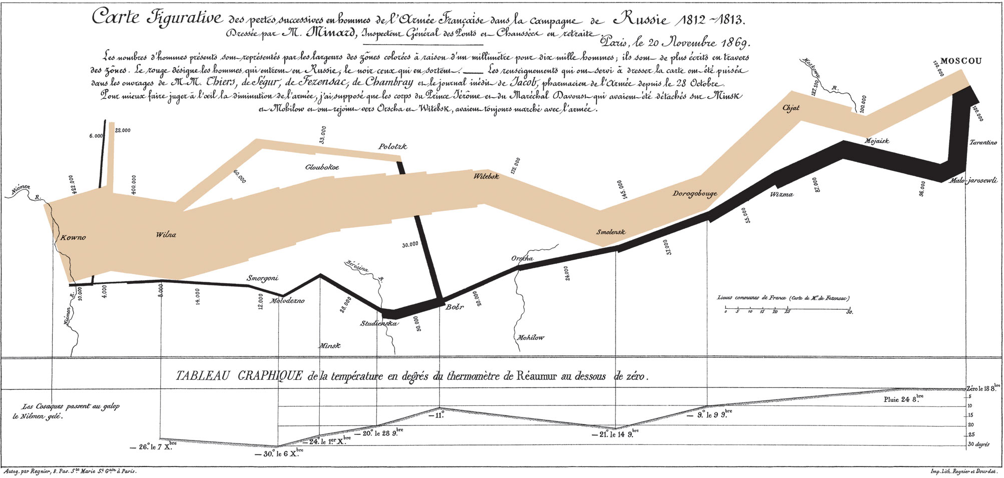
Alluvial Plots are variations of Napoleon’s March to Russia and Sankey diagrams. They shine in many ways:
- showing connections between multiple categorical variables.
- including numeric variables through binning
- creating a storyboard by copying the right most variable to the left of the next plot.
They are implemented in R by the ggalluvial package which is an add on to ggplot2. This capability exists in python and can be replicated in Tableau.
Visualizations: Alluvial Plots by Date and Distance

Visualizations: Alluvial Plots by Habitability and Safety


Data Sources
The Maryland Property Data - Parcel Points, filtered for Montgomery County
This describes all 344K properties in Montgomery County. In addition to property address, it contains key data including geographic location and census block groups that allow it to be joined to both County and U.S. Census data sets. It has interesting items such as property owner; number of dwelling units; and dates of last inspection, sale, and construction. Indicators of owner occupancy and residential property allow filtering of rental property.
Data Montgomery Housing Code Violations
This contains 470K housing code violations dating from 2013. It serves as the primary data source for this project. Although it catalogs only violations, the case number id provides an estimate of total cases including those without infractions. It describes the items in violation, the code citations, corrective actions required and the 311 service complaint. It provides dates of filing, assignment, inspection, correction and closure.
Data Montgomery Troubled Property Analysis
This apparently identifies the properties currently subject to more stringent inspections and corrective action plans. Its case number links back to the Housing Code Violation data set and may be useful to extract other cases with severe violations.
U.S. Census 2018 American Community Survey (ACS) extract for Montgomery County Block Groups
This data set provides estimates of the number of units in owner and renter occupied properties in each census block in Montgomery County. The estimates are based on data sampled between 2014 and 2018.
Other Data Montgomery data sets and text sources to be used in the project include:


