Ecosystem responses to fire in mixed-grass prairie
Preliminary data from the Lemonade Fire
Version date: 05 February 2024
Overview
Wildfire affects a substantial amount of public and private grazingland in the Northwest Great Plains.
Managers often delay or totally defer grazing after a wildfire for up to two seasons. As more allotments are affected, unburned rangeland will increasingly need to absorb additional stocking pressure as managers work to find alternative grazing.
Research with prescribed fire shows that immediate post-fire regrowth provides opportunity for high-quality grazing without damaging the ecosystem. Could the same be true for wildfire incidents?
On Fort Keogh, the mixed grass prairie ecosystem appeared resilient to a late summer wildfire:
- High-severity areas had higher soil nutrients and greater soil microbe abundance
- Standing crop was not substantially different across burned and unburned areas throughout the next season, despite cattle grazing
- Dominant bee families showed divergent responses across the burn perimeter, suggesting the mix of burned and unburned areas is more important to bee communities than the severity of the fire
Key takeaway: Preliminary data suggest the ecosystem is sufficiently resilient to support moderate livestock grazing in the season after a burn
General background
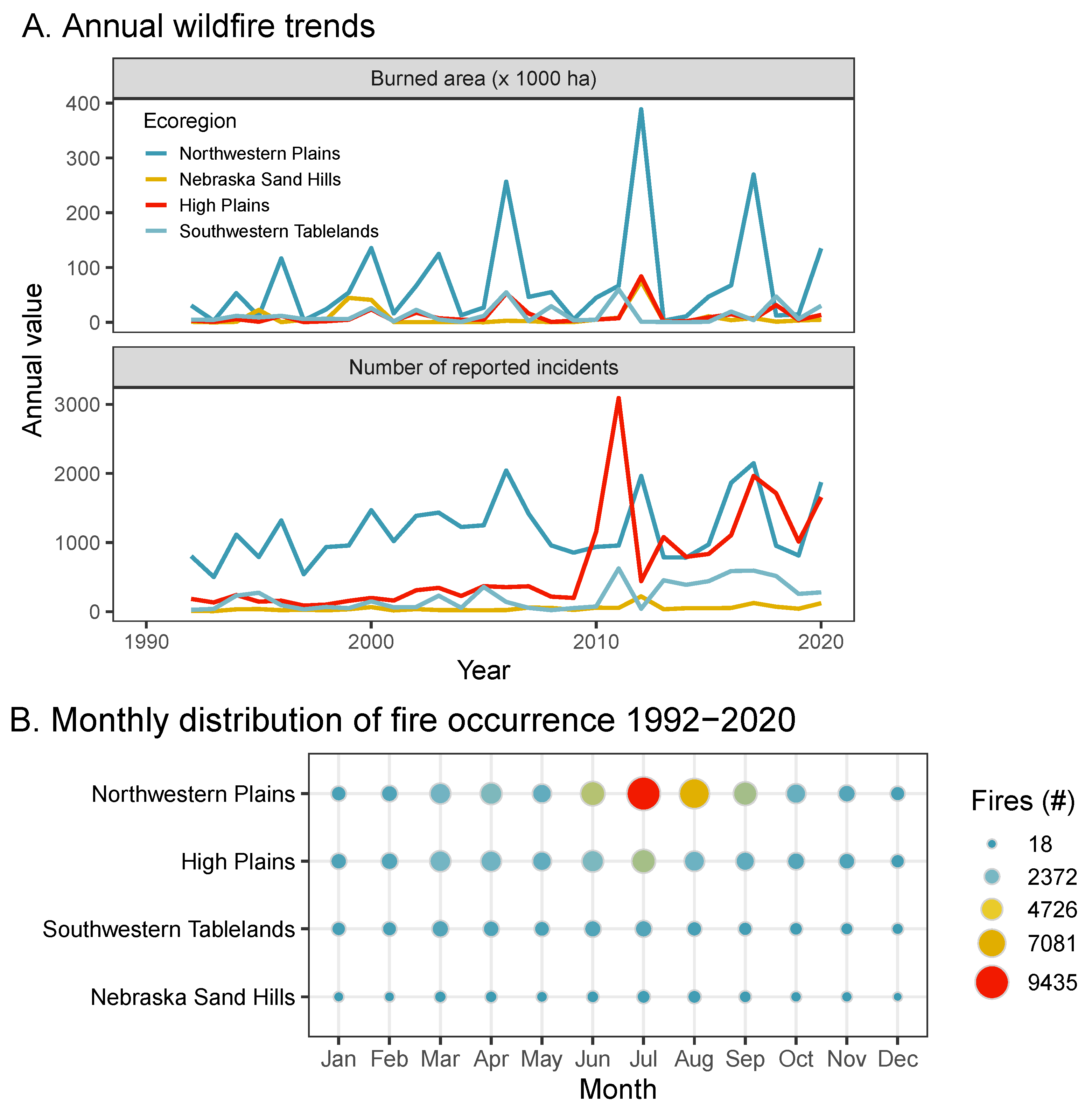
Although there’s a lot of talk about how fire activity—particularly the number of large fires—is increasing across the country, this is not actually the case for our ecoregion, the Northwestern Great Plains. Our recent analysis found that neither the number of wildfire incidents nor total burned area have increased over the last 40 years because both have been consistently high over this entire time period. Although reporting on this is scant and inconsistent, by some measures the NW Great Plains has more fire activity than ecosystems well-known for their frequency of burning, such as cheatgrass-invaded areas of the Great Basin.

L: Level III ecoregions within the Western Great Plains; R: Total area burned by wildfire over 40 years, from the NIFC Fire Occurrence Database, plotted by US census tract.
Fire & public grazinglands
One interesting trend to emerge from the analysis of regional fire data is the increase in the number of BLM allotments being affected by wildfire. While this trend is just as likely to be in the data rather than actual increases in fire activity—e.g., a consequence of better reporting and/or more mapping of incidents, or increasing mutual aid—it is clear that wildfire impacts public grazinglands.
In the last several decades at least 1400 grazing leases in the NW Great Plains were likely re-evaluated due to wildfire.

Northwestern Plains: BLM, 1032 (31%); USFS, 365 (51%)
Grazing and wildfire
Practice/policy: Delay/defer grazing for 1-2 seasons after a wildfire.
Lemonade Fire
An escaped prescribed fire on Fort Keogh that spread through a pasture in which soil and vegetation data had already been collected ahead of planned prescribed burns, and could be stocked with cattle in the season after the fire, provided an opportunity to study how wildfire and cattle grazing affect ecosystem properties in mixed-grass prairie.
Study area

L: X marks Fort Keogh within the Northwestern Great Plains. R: The Lemonade Fire of 22 Sept 2022 covered about 900 acres on Fort Keogh. Severity was determined from LandSat imagery collected just a few days before the burn, and just a few days after.
Data collection
Based on focus group with stakeholders, we designed a study to measure the following responses:
- Soil
- Total elemental nutrients and plant-available nitrogen
- Microbial communities
- 1 week post-fire and summer after
- By severity and ecological site
- Vegetation
- Total aboveground herbaceous (grass + forb) standing crop
- Forage nutritive value
- Paired burned/Unburned plots nested by ecological sites
- Clipped monthly summer after

Results
Soil
Soil analyses at this point are limited to data collected prior to the burn and those collected immediately after the fire (within 1 week, and before any precipitation).
Overall there was a strong seasonal pattern of decline over the seven weeks from pre-burn sampling (mid-August 2022) and post-fire sampling (late September 2022).
Soil nutrients
As expected, overall soil nutrients increased along with burn severity.

Soil microbes
Likewise, abundance of three broad groups of soil microbes increased with burn severity.

Vegetation
Standing crop
Clipping from plots open to cattle grazing—cattle were stocked from June through September—shows there was little difference in standing crop between burned and unburned areas across all ecological sites.

Note these are the raw samples and have not been calculated to reflect per-area productivity.
Pollinators
Inverse patterns in these two bee communities highlight the importance of pyrodiversity on the landscape, and the strong seasonal affect on overall abundance.

Going forward
- Analyze summer soil data
- 3-yr grazing management study w/in grazing exclosures
- Forage nutritive value on all clippings
- More pollinator/invertebrate data
- Spatial analysis of sagrbrush responses