In this chapter we discussed why well-designed data graphics are important and we described a taxonomy for understanding their composition.
The objective of this assignment is for you to understand what characteristics you can use to develop a great data graphic.
Each question is worth 5 points.
To submit this homework you will create the document in Rstudio, using the knitr package (button included in Rstudio) and then submit the document to your Rpubs account. Once uploaded you will submit the link to that document on Canvas. Please make sure that this link is hyper linked and that I can see the visualization and the code required to create it.
Question #1
Answer the following questions for this graphic Relationship between ages and psychosocial maturity
Question #2
Answer the following questions for this graphic World’s top 10 best selling cigarette brands 2004-2007
Question #3
Find two data graphics published in a newspaper or on the internet in the last two years.
Question #4
Briefly (one paragraph) critique the designer’s choices. Would you have made different choices? Why or why not? Note: Link contains a collection of many data graphics, and I don’t expect (or want) you to write a full report on each individual graphic. But each collection shares some common stylistic elements. You should comment on a few things that you notice about the design of the collection.
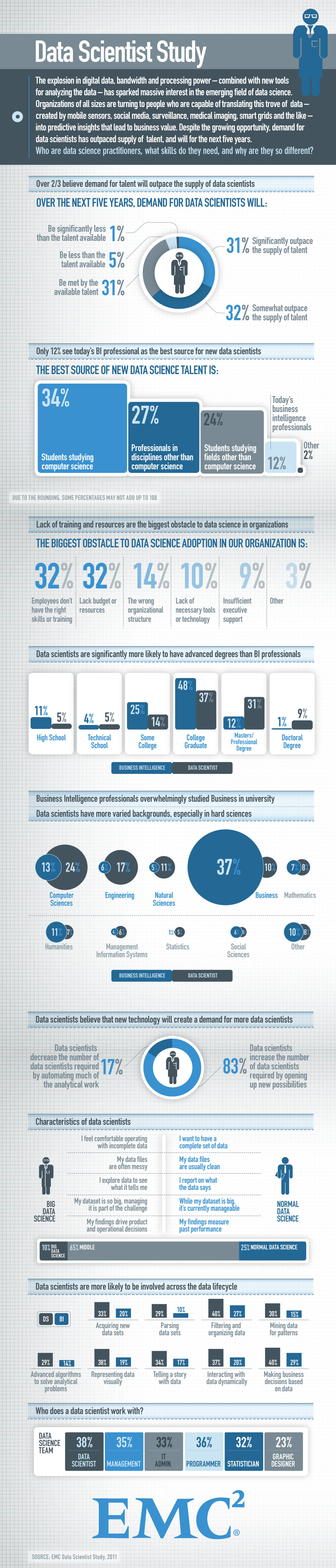
Answer: - Overall it has used one color scale makes it easy to
understand even if it gets print out in black and while late on - first
pie chart explains percentage in different shade easy to identify, with
conclusion line - second, shows area comparison but missing 100%
reference point, may mislead audience
- third, showed fading effect as it changes. Sometime it is hard for
person to understand if the difference is less - moving forward it
include categorical variable with % comparison of business analyst
versus Data scientist based on degrees - data in bubble on other showing
size comparison - Pie chart - iconic representation - Some more
Percentage comparison in form of Bar chart - Departmental shares in Data
science field in business
Question #5
Briefly (one paragraph) critique the designer’s choices. Would you have made different choices? Why or why not? Note: Link contains a collection of many data graphics, and I don’t expect (or want) you to write a full report on each individual graphic. But each collection shares some common stylistic elements. You should comment on a few things that you notice about the design of the collection.
Charts that explain food in America
Answer: these 40 different graphics shows some data based in agriculture. these data contains spacial elements with longitude and latitude that represents different data in United states. It uses different colours, data point size, , 3D maps etc to represent it on the Map.